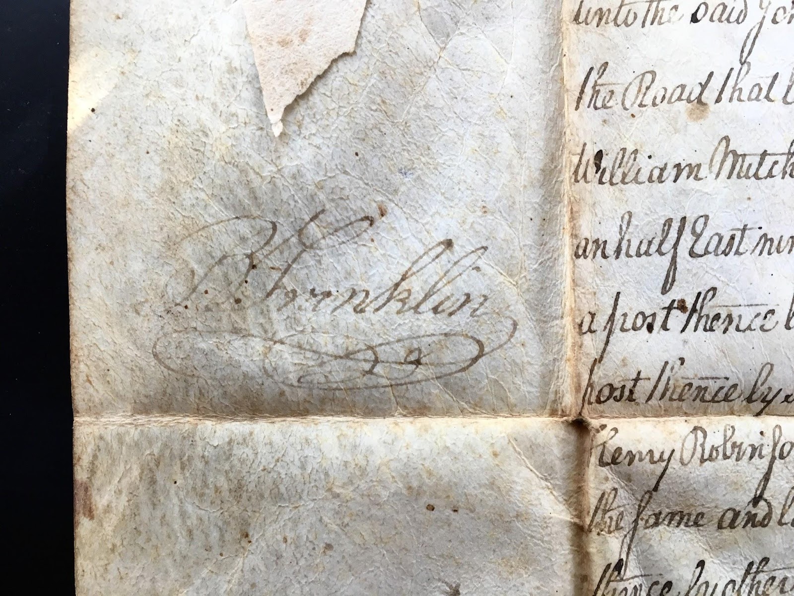
In 1791 ancestors of mine, John & Jane Crozier, purchased the deed to a 36 acre farm from John Pierce Duvaul near Smithfield in Fayette County PA. The deed to this land, purchased by the Duvauls from the Commonwealth of PEnnsylvania in 1787, has been passed down through my family for the last 220 years, though we no longer own the land. This document is recorded on a heavy parchment, with tight, precise script. It was signed by the then president of the Pennsylvania Commonwealth, Benjamin Franklin.

The deed describes a property by the name of “Fancy”. The location is given relative to Georges Creek, which runs south of Smithfield in Fayette County, and a road that runs to Hyde’s ferry. The survey points marking the bounds of the property are given, using trees, rocks, posts, and other nearby farms as markers. Distances are measured out in perches (a perch is the same as a rod, or 16.5 feet).
This document was passed to me because my chosen vocation is urban planning and therefore such a document “might be of interest to me”. It was quite an honor to receive it, and I decided to accept this as a challenge and try to find out what else I could about this old property, to link the abstraction described in the document with reality.
The first line of investigation involved finding the general region of the farm. Fayette County is in south-western Pennsylvania, on the border with Maryland. On the deed the property is placed in Springhill township, however that township was later divided to create Nicholson township. Georges Creek flows south and west from a ridge of the Laurel Highlands into the Monogehela River south of New Geneva (a small town with it’s own interesting past, involving an abortive Swiss colony and the future Secretary of the Treasury of the young United States). I’ve been unable to turn up any trace of a Hyde’s ferry, but I figured it must be either at New Geneva or along the straight, low-banked stretch of the river to the north as far as Masontown. If the farm is on the waters of Georges Creek, but south of the road, then likely the road ran north of the creek.
I found some old maps of Pennsylvania and Fayette county which show several roads running south-west to the river. Some have the farms of the area labeled, including one from 1853, in which I spotted “T. Crozier” near a branch of the creek. Turning to Google Maps I found that this branch was named “Crozier’s Run”. It lies in the hills just above the small town of Smithfield in Nicholson Township. [map] [photo]
I also used Ancestry.com to learn more about my relationship to John and Jane Crozier. Building on genealogy work already completed by other members of my family I found that John and Jane were my great-great-great-grandparents. Their marriage certificate from Amagh County Ireland has been uploaded to Ancestry.com. [image] At this time I do not know more about their heritage in Ireland, whether they had Scotch, Anglo, Irish, or other roots. The word crozier means the staff wielded by a bishop. The term comes from French but is used in English as well.
I also used Ancestry.com to learn more about my relationship to John and Jane Crozier. Building on genealogy work already completed by other members of my family I found that John and Jane were my great-great-great-grandparents. Their marriage certificate from Amagh County Ireland has been uploaded to Ancestry.com. [image] At this time I do not know more about their heritage in Ireland, whether they had Scotch, Anglo, Irish, or other roots. The word crozier means the staff wielded by a bishop. The term comes from French but is used in English as well.
My line of the Croziers did not stay in Fayette County, but gradually moved north, ultimately to Warren, PA, where my father was born. However the 1801 birthplace for my great-great-grandfather, as reported on Ancestry.com, was “Fancy Hills” in Fayette County. He was a preacher and later moved north-west to Elizabeth, PA, where he is buried. Another historic map and a text on local geology both indicate that Croziers remained at the site until the 1870’s at least.
In order to find the exact location of the old property I had to find its size and shape. No overall size is listed on the deed, only the property’s survey coordinates. Based on these coordinates I’ve attempted to draw its boundaries, and compare them with existing properties in the neighborhood.
Here I began to run into dead ends. No existing property matches the boundaries I have drawn. The location indicated on the 1870 map is on a steep hillside, now forested. The property itself, at only 36 acres, was quite small, considering that this was “virgin” territory. I visited Smithfield and found no mention of the Croziers in records of the town's founding and early days or on Tombstones in the cemetery.
A few routes remain to be explored. It is likely there exist more precise maps marking property boundaries in County or library historical records. I knocked on a couple of doors in the presumed neighborhood of the farm to ask if they knew anything about the Croziers or Fancy Hills, but no one was home. I may attempt to reach these folks by mail. There may also be more information available with Nicholson Township.
I walked the roads surrounding the cluster of farms, among which I believe the old Crozier farm was located. There are several very old barns and other structures. Much of the land is forested, most of the rest is used as pasture for cattle. The hills rise abruptly up from the streambeds, and provide grand views to the east. Some of the streams nearby run orange from athracide runoff due to coal mining, but Crozier’s run does not.

I believe I've located the farm, though the property boundaries don’t align with any existing plot as far as I can tell. The land in the immediate vicinity is rugged. Some of it is forested and has been recently logged, some is used for pasture. There are no visible structures. There's a logging road seems to follow the path of an old right-of-way that ran parallel to Crozier's Run. I followed this old over-grown road to where it opened onto a pasture. I trespassed through the property, past open fields, natural gas pumps, and then, under the electric fence twice to bypass some confrontational cows, and back down to the main road making a loop. There are several old farmhouses near there and old structures in the woods off the road. I thought I could try and contact folks to who live around here and I ended up knocking on the doors of two houses but I got no response. I've thought of mailing these people a message, to ask it they know anything about the history of this land or the Croziers of Crozier's Run, but have yet to do so.
For now that's it. It was a fun adventure to try to track down the ancestral plot, if the end was anticlimactic. After I left Smithfield I drove north to visit the more recent ancestral home of the White's, my paternal grandmother's family, south of Pittsburgh in Hickory PA. After a few days in Pittsburgh visiting an old Peace Corps friend and some site's from my dad's time in that city I rode the train to Washington DC, again passing through the green rolling hills of southwestern Pennyslvania following the smooth curves of the Youghiogheny River.

